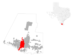
McAllen, Texas
| City of McAllen | |
|---|---|
| — City — | |
| Nickname(s): City of Palms | |
 |
|
| Coordinates: | |
| Country | |
| State | |
| County | Hidalgo |
| Government | |
| - Type | Council-Manager |
| - City Council | Mayor Richard F. Cortez Scott Crane Marcus Barrera Hilda Salinas Aida Ramirez John Ingram Jim Darling |
| - City Manager | Mike Perez |
| Area | |
| - City | 46.3 sq mi (119.8 km2) |
| - Land | 46.0 sq mi (119.1 km2) |
| - Water | 0.3 sq mi (0.8 km2) |
| Elevation | 121 ft (37 m) |
| Population (2000) | |
| - City | 106,414 (city proper) |
| - Density | 2,314.7/sq mi (893.8/km2) |
| - Metro | 569,463 |
| Time zone | CST (UTC-6) |
| - Summer (DST) | CDT (UTC-5) |
| ZIP codes | 78501-78505 |
| Area code(s) | 956 |
| FIPS code | 48-45384[1] |
| GNIS feature ID | 1374829[2] |
| Website | http://www.mcallen.net/ |
McAllen is the largest city in Hidalgo County, Texas, United States. It is located at the southern tip of Texas in an area known as the Rio Grande Valley and is part of the American Southwest. The population was 106,414 at the 2000 census, while the McAllen–Edinburg–Mission Metropolitan Statistical Area had a population of 569,463; rapid growth pushed the metropolitan area's population to 710,514 by 2007.[3] It is the 187th largest city in the U.S. and the 70th largest metropolitan area. Its southern boundary is located about five miles from the U.S.-Mexico border and the Mexican city of Reynosa, the Rio Grande River and about 70 miles (110 km) west of South Padre Island and the Gulf of Mexico.
Contents |
Geography
McAllen is located at (26.216263, -98.236385)[4].
According to the United States Census Bureau, the city has a total area of 46.3 square miles (119.8 km²). 46.0 square miles (119.1 km²) of it is land and 0.3 square miles (0.8 km²) of it (0.63%) is water.
Although McAllen is named the City of Palms, tropical vegetation is only locally dominant. There are many deciduous trees such as Rio Grande Ash (Fraxinus berlandieriana), Cedar Elm (Ulmus crassifolia), Sugarberry (Celtis laevigata) and Honey Mesquite (Prosopis glandulosa). In winter, when these trees are bare, many neighbourhoods take on a much more temperate appearance.
Climate
McAllen has a humid subtropical climate, similar to that of the Tampa Bay Area of Florida but with less precipitation and slightly higher summer maximum temperatures. The average high in January is 70 °F and the average low is 50 °F. The average high is 96 °F and the average low is 76 °F in August. The warm season is extremely long, as average high temperatures are above 90°F (32 °C) and average low temperatures are above 70 °F (21 °C), with relatively high dew point values resulting in higher relative humidity values and heat index values from May through September. Heat index values can consistently reach over 100 °F from May through September.
Average annual precipitation is only 22.96 inches (583 mm). Most precipitation occurs in the warm season, with the least precipitation distinctly occurring in the cooler winter. As September is the peak of the North Atlantic Hurricane Season and tropical storms and hurricanes occasionally drop copious amounts of rainfall on the region, this month tends to be by far the wettest, averaging 4.08 inches (104 mm) of rain. The driest month is March, with only 0.72 inches (18 mm) of precipitation.
Temperatures are frequently above 100 °F (38 °C), occasionally as early as February and as late as the end of October, the highest temperature ever recorded in McAllen is 110 °F (43 °C), once in 1998 and once in 1999. The lowest temperature ever recorded in McAllen is 13 °F (-11 °C), on January 12, 1962.
| Climate data for McAllen, Texas | |||||||||||||
|---|---|---|---|---|---|---|---|---|---|---|---|---|---|
| Month | Jan | Feb | Mar | Apr | May | Jun | Jul | Aug | Sep | Oct | Nov | Dec | Year |
| Source: National Weather Service[5]'' | |||||||||||||
Demographics
As of the census[1] of 2000, there were 106,414 people, 33,151 households, and 26,089 families residing in the city. The population density was 2,314.7 people per square mile (893.8/km²). There were 37,922 housing units at an average density of 824.9/sq mi (318.5/km²). The racial makeup of the city was 78.46% White, 0.61% African American, 0.40% Native American, 4.93% Asian, 0.04% Pacific Islander, 15.85% from other races, and 2.71% from two or more races. Hispanic or Latino of any race were 77.28% of the population.
There were 33,151 households out of which 43.2% had children under the age of 18 living with them, 59.0% were married couples living together, 16.0% had a female householder with no husband present, and 21.3% were non-families. 17.9% of all households were made up of individuals and 6.4% had someone living alone who was 65 years of age or older. The average household size was 3.18 and the average family size was 3.64.
In the city the population was spread out with 30.8% under the age of 18, 10.5% from 18 to 24, 29.3% from 25 to 44, 18.9% from 45 to 64, and 10.4% who were 65 years of age or older. The median age was 30 years. For every 100 females there were 90.1 males. For every 100 females age 18 and over, there were 85.8 males.
The median income for a household in the city was $33,641, and the median income for a family was $36,050. Males had a median income of $30,089 versus $22,480 for females. The per capita income for the city was $14,939. About 20.9% of families and 23.8% of the population were below the poverty line, including 30.5% of those under age 18 and 20.3% of those age 65 or over.
| Historical populations | |||
|---|---|---|---|
| Census | Pop. | %± | |
| 1910 | 150 |
|
|
| 1920 | 5,331 | 3,454.0% | |
| 1930 | 9,074 | 70.2% | |
| 1940 | 11,877 | 30.9% | |
| 1950 | 20,067 | 69.0% | |
| 1960 | 32,728 | 63.1% | |
| 1970 | 37,636 | 15.0% | |
| 1980 | 66,281 | 76.1% | |
| 1990 | 89,000 | 34.3% | |
| 2000 | 106,414 | 19.6% | |
Transportation
Mass transit
Public Transportation for the City of McAllen began in June 1997. In the beginning, McAllen’s public transportation system, McAllen Express (ME), was administered by the Lower Rio Grande Development Council. Since 2005, McAllen Express Transit (MET) has been operated as a Department of the City of McAllen. MET now has seven fixed routes serving residents and visitors of McAllen. MET operates six days out of the week, 13 hours per day. In 2003, changes in the census affected McAllen’s urbanized area, and MET lost $1.5 million in operating funds. Nonetheless, the City of McAllen has worked diligently to ensure that service levels are maintained, and continues to plan for service improvements. Ridership in 1997 totaled 42,578 passenger trips. The first full year of operation was in 1998, and the ridership recorded for that year was 201,506 passenger trips. In 2008 McAllen Express Transit accomplished record high numbers in ridership, totalling 412,151 passenger trips, accounting for more that twice the ridership recorded in 1998.
MET FARE STRUCTURE
| Adults | Students | Elderly |
|---|---|---|
| $1.00 | $0.50 | $0.50 |
The City of McAllen also operates the bus terminal facility in downtown McAllen, known as McAllen Central Station. Central Station serves as a hub for MET as well as 14 private domestic and international bus lines. Approximately 60 buses depart from Central Station on a daily basis. Central Station also hosts 2 million visitors per year. McAllen Central Station has been the first successful terminal of its kind in the region and has become a model facility for agencies such as Brownsville, Houston, and Baytown.
Highways
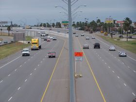
U.S. 83 travels through McAllen as its major east-west artery. It runs less than a mile south of downtown McAllen.
Airports
- McAllen-Miller International Airport[6] as of 2009 it is the Rio Grande Valley's busiest airport. It is served by American Airlines with non-stop service to Dallas/Ft. Worth, Continental with non-stop service to Houston, Allegiant Airlines with non-stop flights to Las Vegas and Orlando-Sanford, and Northwest/Delta Airlines with non-stop service to Memphis, Tenn.
- South Texas International Airport at Edinburg located 9 miles (14 km) north of Edinburg. An uncontrolled airport with 5000' paved runway, customs on demand and self service fuel.
Economy
Prior to ratification of the North American Free Trade Agreement, economic activity in McAllen was centered around agriculture and petroleum.
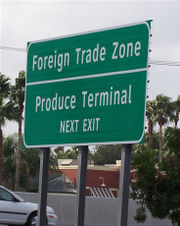
A Foreign trade zone is located on the southwest side of the city. In addition to the industrial activity, there is a retail sector that is heavily dependent on purchases made by wealthier, and largely, Mexican middle and upper middle-class consumers. This sector benefits greatly from the express highway links, on the Mexican side of the border, to Monterrey, Cd. Victoria and Tampico.
A Forbes article on the internet list McAllen as one of the best real estate markets in the United States.
McAllen has the second highest per capita health-care costs in the United States.[7]
Media and journalism
Television stations
- XHRIO 2 Matamoros, Tamaulipas Fox Official Site
- KGBT 4 Harlingen, Texas CBS
- KRGV 5 Weslaco, Texas ABC
- XHAB 7 Matamoros, Tamaulipas Televisa
- XERV 9 Matamoros, Tamaulipas XEW
- XHREY 12 Reynosa, Tamaulipas TV Azteca 13
- XHOR 14 Reynosa, Tamaulipas TV Azteca 7
- KVEO 23 Brownsville, Texas NBC
- KTLM 40 Rio Grande City, Texas Telemundo
- KNVO 48 McAllen, Texas Univision Official Site
- KTIZ 52 Harlingen, Texas The CW
- XHVTV 54 Reynosa, Tamaulipas Multimedios
- KMBH 60 Harlingen, Texas PBS
- MCN 12 McAllen, Texas McAllen Cable Channel[1]
Radio stations
- KCAS The New KCAS 91.5 FM -
- KURV 710 AM News Talk Radio
- XERDO LA RADIO 1450 AM (Spanish Oldies/News)
- XEMS Radio Mexicana 1490 AM (Regional Mexican)
- XHRYS Uni 90.1 FM (Spanish Hit Radio)
- XHRYN Uni 90.5 FM (Spanish Hit Radio)
- XHRYA MasMusic 90.9FM (Bilingual Hit Music)
- XMLS EXA 91.3 FM (Spanish Hit Radio)
- XHAAA La Caliente 93.1 FM (Mexican Norteño)
- KFRQ Q94.5 FM (Classic/Modern/Hard Rock) Official Site
- XHRT Xtrema 95.3 FM (Spanish Hit Radio)
- KBTQ Recuerdo 96.1 FM (Mexican Oldies)
- KVMV Family Friendly & Commercial Free 96.9 FM (Adult Contemporary Christian)
- KGBT-FM Solamente Exitos 98.5 FM (Mexican Norteño)
- KKPS Que Pasa 99.5 FM (Local Tejano Music) Official Site
- KTEX South Texas Country 100.3 FM (Country)
- KNVO-FM Super Star 101.1 FM (Bilingual Hit Music) Official Site
- XHAVO 101.5 FM 92.7 Musica International
- KBFM Wild 104.1 FM (Hip-Hop/R&B)
- KJAV The Jack 104.9 FM ("Jack" Format)
- KQXX The X 105.5 FM (Classic-rock)
- KHKZ Hot Kiss 106.3 FM (Hot AC) Official Site
- XHVTH La mas buena 107.1 FM (Mexican Norteño)
- KVLY Mix 107.9 FM (Hot AC) Official Site
Magazines
- Contempo Magazine(print monthly and online daily)owned by Contempo Magazine,Inc.McAllen Official Site
- RGVmag (printed monthly) owned by Fantich Media.Official Site
- MagX (printed monthly) owned by MagX. Official Site
Area newspapers
- The Monitor is headquartered in McAllen
- Valley Morning Star
- The Brownsville Herald
- El Periódico USA - Spanish Language Newspaper - Headquartered in McAllen http://www.elperiodicousa.com
- Town Crier
- The Business Times http://www.rgvbiztimes.com
- ¿qué pasa? - a virtual newspaper and event guide - Official Site
Government and infrastructure
The Texas Department of Criminal Justice (TDCJ) operates the McAllen Parole Office in McAllen.[8]
The United States Postal Service operates two post offices in McAllen, including the McAllen Post Office and the Downtown McAllen post office.[9][10]
Education
Area colleges and universities
- University of Texas–Pan American (approximately 17,000 students as of August 2007) in Edinburg
- South Texas College (over 27,000 students spread across their 5 campuses and the eSTC virtual campus)
Primary and secondary schools
McAllen Independent School District serves most of the city. Portions of the city extend into Edinburg Consolidated Independent School District and that district operates two elementary schools located in the City of McAllen. The Hidalgo Independent School District, La Joya Independent School District, Pharr-San Juan-Alamo Independent School District, Sharyland Independent School District, and Valley View Independent School District also serve the City of McAllen.
In addition, residents are allowed to apply to magnet schools operated by the South Texas Independent School District. Idea Public Schools also has Quest Academy in North McAllen (mile 17 &1/2 and Rooth road).
Public libraries
McAllen Public Library operates a main library and two branches, the Lark Branch and the Palm View Branch.[11]
Architecture and points of interest
- Tallest buildings
- Chase Texas Tower (tallest tower in McAllen)
- BBVA Compass Tower
- Bentsen Tower
- Embassy Suites Hotel
- Mcallen Medical Center
- Rio Grande Regional Hospital
- Gardens
- McAllen Botanical Gardens
- Santa Ana National Wildlife Refuge
- Quinta Mazatlan
- Others
- Microsoft Repair Shop
- Mcallen Convention Center
- La Plaza Mall
- Rio Grande Speedway
- State Farm Arena(Hidalgo,Texas)Hidalgo, Texas
- South Texas College
- International Museum of Art
- Cine El Rey
- Things to do in McAllen Texas/Rio Grande Valley
Surrounding cities
Nearest cities
- Cities within 30 miles (48 km)
- Alamo, Texas
- Donna, Texas
- Edinburg, Texas (County seat of Hidalgo County and home to the University of Texas Pan American, the major institute of higher education in the McAllen metro area.)
- Hidalgo, Texas (home of the State Farm Arena, an indoor professional sports and music concerts venue serving the McAllen metro area)
- Mercedes, Texas
- Mission, Texas
- Pharr, Texas
- Reynosa, Tamaulipas (Mexico)
- San Juan, Texas
- Weslaco, Texas
Nearest major cities
- Cities with a population over 250,000 within 200 miles (320 km)
- Corpus Christi, Texas
- Laredo, Texas
- Matamoros, Tamaulipas
- Monterrey, Nuevo León
- Nuevo Laredo, Tamaulipas
- Reynosa, Tamaulipas
Recreation and Sports
Birdwatching - The McAllen is positioned on the migratory path between North and South America, presenting bird and butterfly expeditions. The landscape hosts a diverse wildlife population.
McAllen has hosted the NAIA national football championship and NCAA Division II national football championship games in the 1980s. McAllen is home to Rio Grande Speedway, a 1/4 mile dirt track with races the 1st, and 3rd Saturday of each month from March through November, and a national multi-day event around December.
See also
- Veterans War Memorial of Texas
References
- ↑ 1.0 1.1 "American FactFinder". United States Census Bureau. http://factfinder.census.gov. Retrieved 2008-01-31.
- ↑ "US Board on Geographic Names". United States Geological Survey. 2007-10-25. http://geonames.usgs.gov. Retrieved 2008-01-31.
- ↑ "Annual Estimates of the Population of Metropolitan and Micropolitan Statistical Areas: April 1, 2000 to July 1, 2007 (CBSA-EST2007-01)" (CSV). 2007 Population Estimates. United States Census Bureau, Population Division. 2008-03-27. http://www.census.gov/popest/metro/tables/2007/CBSA-EST2007-01.csv. Retrieved 2008-05-02.
- ↑ "US Gazetteer files: 2000 and 1990". United States Census Bureau. 2005-05-03. http://www.census.gov/geo/www/gazetteer/gazette.html. Retrieved 2008-01-31.
- ↑ National Weather Service Brownsville
- ↑ website
- ↑ Gawande, Atul (2009-06-01). The Cost Conundrum: What a Texas town can teach us about health care. The New Yorker. http://www.newyorker.com/reporting/2009/06/01/090601fa_fact_gawande?currentPage=all. Retrieved 2009-08-31.
- ↑ "Parole Division Region IV." Texas Department of Criminal Justice. Retrieved on May 21, 2010.
- ↑ "Post Office™ Location MCALLEN." United States Postal Service. Retrieved on May 9, 2010.
- ↑ "Post Office™ Location - DOWNTOWN MCALLEN." United States Postal Service. Retrieved on May 9, 2010.
- ↑ "Main Library." McAllen Public Library. Retrieved on May 9, 2010.
External links
- Official Website
- exploreMcAllen.com - New portal website for the City of McAllen
- McAllen Chamber of Commerce
- McAllen Economic Development Corporation
- McAllen Foreign Trade Zone
- The Handbook of Texas Online
- ¿qué pasa? - the Rio Grande Valley event guide
- McAllen Citizens League
- Association of Importers & Exporters of Texas
- www.sirkingston.com
|
|||||||||||||||||
|
|||||||||||||||||
|
||||||||||||||||||||||
|
|||||||||||||